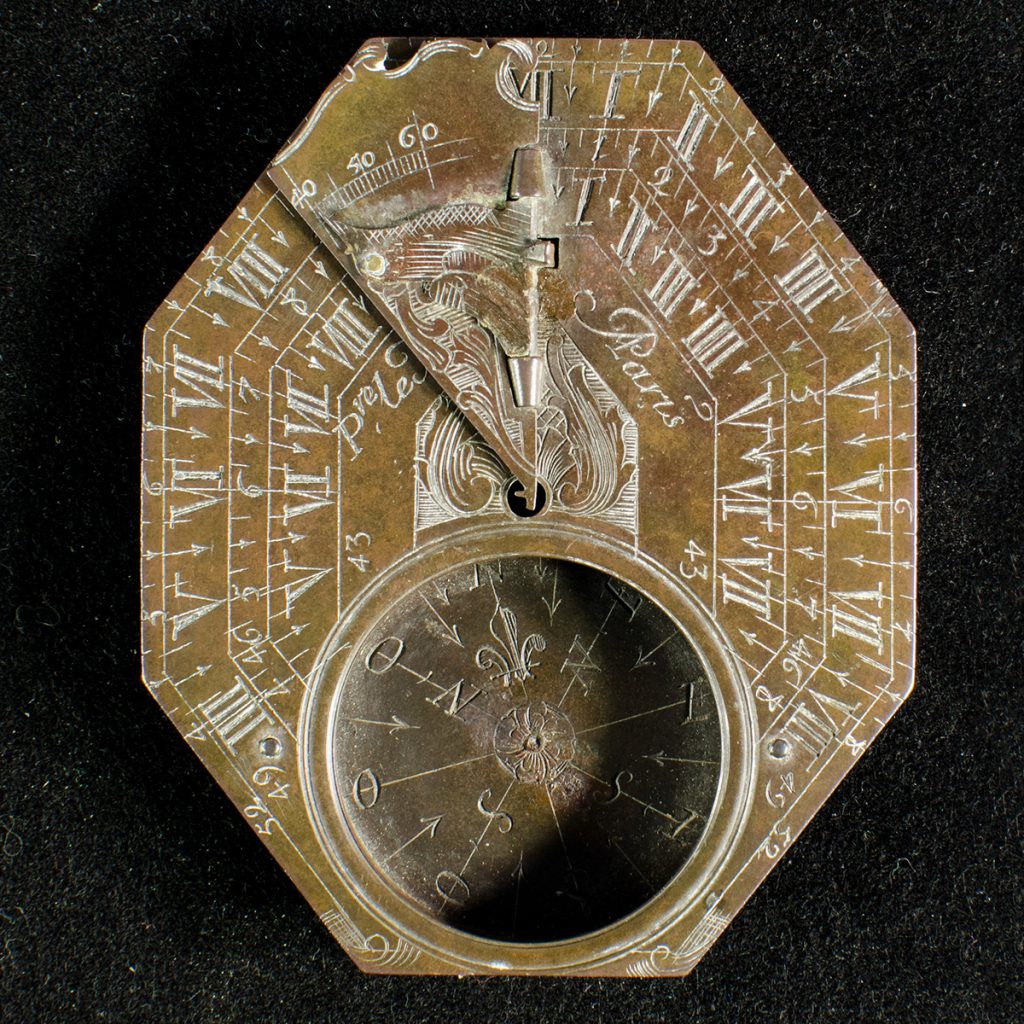
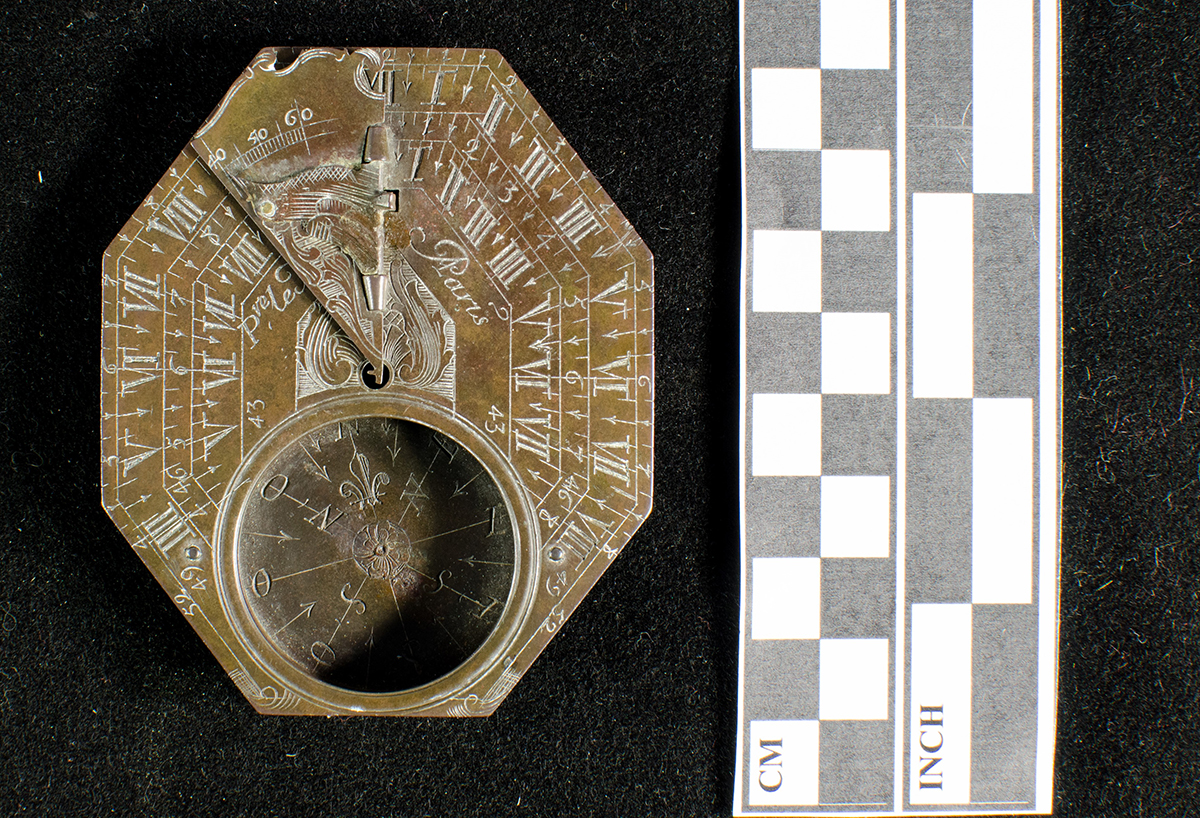
The Le Maire Sundial is a rare example of a mid-18th century French sundial (cadran solaire) compass (boussole). It was found near Green Bay in 1902 by a local antiquities collector, Frank Duchateau.
The sundial is broken, missing its glass compass cover as well as the back of its gnomon holder. Located on the front surface, beneath a bird-shaped gnomon (the part of the sundial that casts a shadow), is a hand engraved maker’s name indicating that the sundial was made in Paris, France: P’re Le Maire à Paris. Sundials of this type were distributed to French officers of New France in the 1750s.
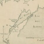
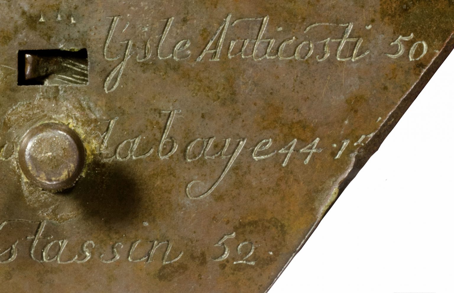
The compass’s reverse (pictured above with a grey background, above) lists the names and latitudes of fifteen French forts, trading posts, and American Indian settlements between Nova Scotia and lower Lake Michigan. The most notable of these places to Wisconsin history is La baye 44.15, known today as Green Bay. It is likely that this navigational instrument was owned by a French officer stationed at La Baye (Green Bay) during the latter half of the 1750s.
The mid-eighteenth century equivalent of today’s GPS, this sundial compass would have guided French officers along maritime highways stretching from the Atlantic Ocean to the southern end of Lake Michigan.
Written by Kevin Cullen, December 2016.

This object has been featured on WPR's Wisconsin Life!
Produced for Wisconsin Life by Erika Janik
The mid-eighteenth century equivalent of today’s GPS, this sundial and compass, would have guided French officers along maritime highways.
Listen below to the segment from Wisconsin Public Radio’s Wisconsin Life.
Erika Janik:
The Le Maire sundial compass was the mid-18th century equivalent to today’s GPS. It was found near Green Bay in 1902 and recalls a time when Wisconsin was part of New France. As part of Wisconsin 101 Kevin Cullen brings us the story.
Kevin Cullen:
The size of the object is a little, you know, unassuming, and it tells an enormous story. It’s something that fits in the palm of your hand that lists the names of Quebec, Montreal, il Anticosti, which is the island right when you enter the St. Lawrence river on the Atlantic Ocean, and right below that is La Baye, La Baye, Green Bay, at latitude 44.15. So, to have a compass and a sundial together, yes, it made sense. At this stage of scientific instrumentation in Europe, it was becoming, it’s like, kind of like our mobile phone today, where it starts you combine technologies, especially for navigation, into a handheld device. So you know, this is the equivalent of an 18th century GPS device.
They were issued to military officers. And we know who some of those folks were at the very end of the French regime here in Green Bay, but it’s likely that they would have had to traverse, certainly, through the highway, the maritime highway that is, you know, from the Atlantic coast. And right below that is Le Baye on the other end, really, of that navigation route, which you’d have to cross all of the Great Lakes practically, to get to.
We know it was made by Pierre Le Maire in a factory, well, probably a small workshop, really, in Paris in France. And based on the inscriptions, the size of it, the combination sundial compass that it dates to that then early 18th century, so early 1700s to mid 1700s. By looking at the inscription of the style of calligraphy, I was curious to see, well, certainly that’s the name brand that they use. So Pierre Le Maire, by comparing the writing on the backside, I was curious to see if that was added later, perhaps by a navigator that knew New France better than somebody in a workshop in Paris. But it turns out it actually looks very, very close to the script that “Pierre Le Maire, Paris” is written on the front side. And so that says that those names and those latitudes were known to people, the Parisians at the time.
The great mystery of who actually held the object. I mean, that’s that’s always going to be the enigma of this piece, where we may never know, but we do know the time period. And you know, there was French military officers that were stationed here in the same period of when we know this was made. It didn’t come from aliens. I’ll just tell you that.
Wisconsin, as we know it, as we call it today, was on the world map over 300 years ago, if not longer. And so we think of 1848 as our founding but, you know, and a very Germanic often, you know, kind of heritage. But I think what the combination sundial, compass, it tells you is it shows that we were as connected back then to a bigger geopolitical sphere than we are even today. And I think that’s that tells something about the importance of this location of the state of Wisconsin, the location of Green Bay on the Fox River as a major now international port.
Erika Janik:
Wisconsin 101 is a collaborative effort to share Wisconsin’s story in objects. Wisconsin Life is a co-production of Wisconsin Public Radio and Wisconsin Public Television, in partnership with the Wisconsin Humanities Council. Additional support comes from Lowell and Mary Peterson of Appleton. Find more Wisconsin Life on our website, wisconsinlife.org and on Facebook. I’m Erika Janik.

Neville Public Museum of Brown County
The Le Maire Sundial is part of the collection of the Neville Public Museum of Brown County. Research for this object essay and its related stories was supported by the museum.